Land Features:
Being an island, Hermit Island has plenty of specific land features and physical features which give the island its character. These land features are separate from the beaches, which were mentioned in the activities section of this guide. Please note that some of these land features are very hard to access, and be careful if doing so.

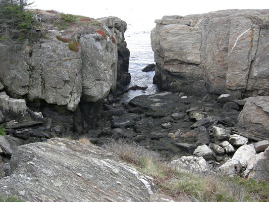
The Bath Tub: The bath tub is actually a small, skinny cove located off of Sunset Lagoon. It is stuck in between breakwater point and the mainland on the southern coast of the island. The bath tub gets its name from its warm water at certain times during the day. At high tide, it is a great place for swimming, but always be careful because sometimes the ocean can be very ruff in the cove. It is best to swim when high tide is at the end of the day so the rocks at the bottom are warmed by the sun then the rocks warm the water when the time comes in. To access the bath tub, you have to hike over the point then down into the cove. It is easiest access from hiking along the rocks to various trails along the point from Lagoon Beach or West Dune Beach. Please note to be careful when hiking to the bath tub because the point is very dangerous, and on top of the poison ivy, there are many dangerous cliffs along the point. Even so, when the water is warm, it is definitely worth the swim. (see picture at middle of page)
Boat Trailer Lot: This lot is actually an open field located right near the marina on the northern half of the island. It is located right off of Island Road, and is used for storing boat trailers in, since there is no parking for them on the island. If you are coming to the island with a boat trailer, then parking for the trailer is available here. It is also a great place to park a regular trailer if you are bringing more stuff and staying on the island longer. In either of these cases, be sure to contact the island for availability, but parking there is still free. Please note that this lot is for trailers only, cars are not allowed, and there is no beach parking available in the lot. Finally, if you are lucky, the island sometimes stores piles of firewood here, which are free for the taking. To access the lot, take Island Road out to the northern tip, then take a left into the lot after the hill in the road from the marina.

Above: Breakwater Point amongst the pristine waters of the Bath Tub on the left, Sunset Laggoon in the foreground, and Casco Bay in the background.
Bounty Cove: Bounty Cove is a small cove on the northern tip of the island that shelters a small white sand beach inside of it. Even so, that is pretty much all you can do there. Boating into the cove is not possible as there is a dangerous rocky shoal at the edge of the cove. Bounty Cove Beach is a very popular beach though, and is great for swimming and sunbathing at because of the hidden location of the beach and the warm water of the cove. To access the beach and the cove, take Island Road to the Bounty Cove Beach parking lot (it is small and unmarked) at the northern end of the road right before Sand Dollar Beach. You can also park at the larger Sailboat Beach parking lot and walk the marked walking path from the edge of Sailboat Beach to the cove. Closest bathroom facilities for the beach are located at Sailboat Beach.
Breakwater Point: Breakwater Point is a popular fishing spot on the island because of how it juts into the water. The rocks located along the point are a great place to fish or enjoy the views of the ocean. Even so, hiking out onto the point is very dangerous as there are many cliffs and other ledges. Even so, the point has system of small hiking trails that run along the point. Be aware of the poison ivy though. To access the point, join the system of hiking trails from Lagoon Beach or West Dune Beach. Swimming warm waters of the bath tub is also a popular pastime on Breakwater Point. (see picture at middle of page)
Casco Bay: Casco Bay is the bay that the island sits in the middle of. Actually, the island sits at the end of Casco Bay before it joins with the Atlantic Ocean. Since the island is surrounded by the bay, the waters of the ocean are very warm, making it great for swimming. Casco Bay also is home to tons of lobster and fish, making it great for fishing or Lobstering. Chances are you will constantly see both fishing and lobster boats going by in the bay. (picture below)
Above: Often wind swept Joe's Head is a favorite among campers because of the amazing ocean and beach views right from the campsites on top of the head.
Giant Anchor: The giant anchor is a manmade anchor which is located on top of the hill near the entrance to the campground. It is a great place for picture taking, just take caution when climbing on the anchor. The giant anchor has become the island’s trademark, as it shows the campgrounds relationship with the ocean. The anchor is located at the intersection o Lee Side Way and Island Road, and welcomes visitors to the island on their way into the campground.
Gooseberry Isle: Gooseberry Isle is a small island located off of the southern shore of the island. Many people enjoy boating out to the shaded island for picnics and the great views of the isle from Joe’s Head. Please be aware that landing on the island is still very dangerous as there are plenty or large rocks that surround the island. Gooseberry Isle can be reached by boat, and the easiest place to launch is from either Sand Dune Beach or West Dune Beach. The island is currently uninhabited.
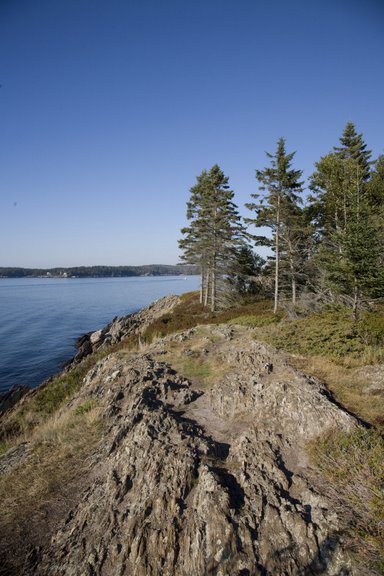
Joe’s Head: Joe’s Head is one of the highest points on the ocean, a rocky bluff that has outstanding views of Casco Bay from all around. Joe’s Head contains ten campsites, which are either prime sites or ocean prime sites. All of the ocean prime sites are located out in the open, with amazing views of the ocean. The bluff also contains two roads; the main road is Joe’s Head Road and there is a smaller road off of the main road called Ocean Sweep. Joe’s Head stretches out into Casco Bay on the southern shore of the island, and is a great place for people who want a campsite with amazing views. In fact, Joe’s Head has constantly been rated by campers as having the most astounding views on the island, all right from your own campsite. To access Joe’s Head, start on Lee Side Way, then take you’re first left onto Joe’s Head Road. After going up the hill at the beginning of the road, you will be on Joe’s Head.
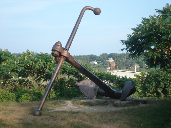
Above: The giant anchor atop the hill at the corner of Island Road and Lee Side Way has become the island's signature as it welcomes campers back to the island year after year.
Lily Pond: The lily pond is the only body of water that is located on the island. It is a natural pond, and gets its name from the hundreds of lily pads that fill the water. The pond is also a great place for nature observation, as there are many different types of birds that live by it, as well as some fisher and a beaver or two. Even so, the pond is also home to hundreds of mosquitoes, so campsites that border the pond tend to have a lot of mosquitoes. Pond front campsites include 4 and 5 Jibe Way as well as 6 Fairlead. One final note is that during heavy rain, the pond tends to flood onto Fairlead, so do not attempt to travel down Fairlead during heavy rain. Please note that boating is not allowed on the lily pond. To access it, take Lee Side Way to Dune Way, followed by taking your first left onto West Dune Way and then your first right onto Fairlead. The pond will then be on your left off of Fairlead.
Lobster Pond: One of the places on the island that absolutely no one knows about is a natural bay in the harbor that the island has closed off and used as a natural lobster pond. Live lobsters are stored in the pond, and then taken out when the price of lobster is high and sold at the island’s store. It is basically the island’s way of controlling the price of lobster, by containing them in a huge pond to be kept longer. The lobster pond is located right next to the island marina, and is shown on the map as the water area between the two bridges by the marina. The first bridge that heads from Island Road to the marina is open to the public and you can walk over it, going by the lobster. Chances are you will not see any lobster, but it is still a fun thing to see. Parking for the lobster pond is available on the mainland side of the marina bridge, by the pondkeepers house.
Osprey Point: Osprey Point is a high rocky bluff that juts out over Casco Bay, with great views of the ocean as well as Sunset Lagoon. It is also one of the most reserved camping areas because of the amazing views from the point. Osprey Point contains only one road, Cross Island, and four campsites, all of which are ocean prime sites. The views from these campsites are stupendous, making them very popular. The point is also very close to the start of the hiking trail system. To access Osprey Point take Lee Side Way to Island Road, followed by a left turn onto Haul/Cross Island. Go all the way down Cross Island to the intersection of Western Reach, then continue straight up the hill onto Osprey Point. Osprey Point has been a family favorite for generations. (see picture below)
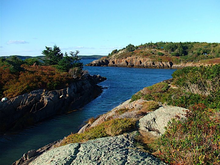
Above: The Bath Tub with Breakwater Point on the left, Sunset Lagoon behind the Bath Tub, and Osprey Point in the background.
Small Point Harbor: Small Point Harbor is the harbor that is located on the eastern shore of the island. It is connected to Casco Bay, but is much more peaceful and protected. Small Point Harbor is a favorite place for fisherman as there is an abundance of lobster and fish in the harbor plus many fishermen use it as a place to park their boat. The sites along the harbor also make a great place to launch or boat or for fishing from the shore. The harbor contains two islands, Wire Island and Tennants Island, and is accessible by water by boating around the point of the island. Finally, a favorite pastime on the island has been to dig for clams in the mud flats that are located at the southern end of the harbor by the island store. A license is required for clamming and can be purchased at the Kelp Shed. It is also free for children under sixteen.
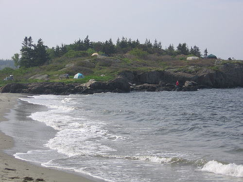
Sunset Lagoon: A large lagoon that is located on the western shore of the island, this lagoon has been a popular spot for sunset viewing. The lagoon is very peaceful, and shelters a beach, Lagoon Beach, plus another cove called the Bath Tub. Even so, the lagoon is dangerous for swimming in as there are very shallow rocks in the water right off of the shore, so the best thing to do in the cove would be kayaking or canoeing. The beach itself has been known to be very quiet and uncrowned. The easiest way to access Sunset Lagoon is by going to the beach. To get to the beach take the two access trails, one to the left of site 66N West Dune Way or the other to the right of 70 West Dune Way. You could also access the lagoon by boating around Breakwater Point and then into the cove. (picture below)
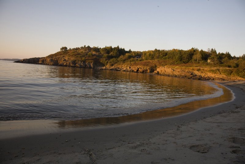
Above: Sunset Lagoon and Lagoon Beach entice those who come to kayak in the cove or relax on the beach for a beautifull sunset over the pristine water.
Tennants Island: Tennants Island is a small, skinny island located in the harbor right off the eastern shore of the island. That is pretty much all it is, a small island with a few trees on the southern end of it. Even so, the island makes a great place for picnicking and boating to, as the water in the harbor is calm enough to land on the island.
The Branch: The branch is the island’s name for Small Point Harbor. (see Small Point Harbor listing)
Wire Island: Wire Island is another extremely small island located in Small Point Harbor. There are no trees on it, just bare rock. It is still fun to boat to the island, but otherwise that is pretty much all you can do.
Worumbo: The worumbo is a large cove located on the western shore of the island. It is extremely deep and scenic, making it great for sightseeing. Otherwise, the cove is very dangerous, so swimming is extremely cautioned. The worumbo is amazing at sight, and can be viewed by hiking along the red trail, part of the island’s trail system. You will also see many other smaller coves located along the red trail, all of which are awe inspiring. The worumbo was just large enough to receive a name.